Keeping an eye on Tropical Weather 2024

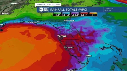
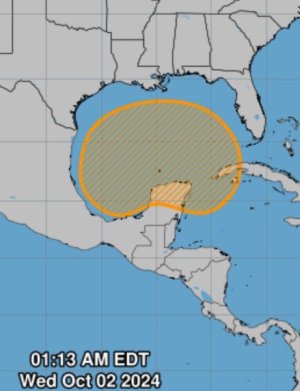
Quoting Denise Philips ABC Action News
“2am update. No changes to NHC thoughts. Still 40%. Looks like we have another "Stalking Turtle" scenario. 🐢 Whatever develops (if anything), it's gonna hang in the Gulf for the next week. Either way, models still having a tough time deciding what to do with it and more importantly, most keep it rather weak. Just check in from time to time for updates. Little to worry about at this point.”

IMG_6409.jpeg
 
And now it is gone…
No it is still there but it has slowed down and has not currently developed further. First, a weak disturbance will head into the Gulf of Mexico over the next several days. For now, it has a 40% chance of developing.

"Especially once it gets into the Gulf, that's when we have to watch that," WPTV First Alert Weather meteorologist Jennifer Correa said. "So the timing of that, when it gets into the Gulf, won't be until maybe Friday or, if not the weekend, into early next week."

Dave
 

No it is still there but it has slowed down and has not currently developed further. First, a weak disturbance will head into the Gulf of Mexico over the next several days. For now, it has a 40% chance of developing.


Dave

When I took the screen shot it was gone. If it's back now, that's happened since.
 
When I took the screen shot it was gone. If it's back now, that's happened since.
These were posted at 2am this morning on Denis’ fb page. I think because it’s not even a TD and not really formed yet, that it doesn’t show on the maps you’re looking at. It’s still 40% chance of forming into one.
 

Attachments

  • IMG_6423.jpeg
    IMG_6423.jpeg
    58.9 KB · Views: 9
  • IMG_6422.jpeg
    IMG_6422.jpeg
    38.1 KB · Views: 8
So it's looking like hopefully things might be ok next week...? How bad is the chance of it forming? Like parks closing party cancelled? or just rain?
 
How bad is the chance of it forming? Like parks closing party cancelled? or just rain?
40% chance of developing into a Tropical Depression in the next 7 days which equals a Medium change of development. No clue yet on any impact to the Florida peninsula and Orlando.

Dave
 
We went to TL on a very rainy day when my boys were 11-12 and had a great time. Was like playing in the rain and swimming at the same time. Rode crush and gusher 50 times at least. The water felt great because the rain was a little cooler so as you climbed the steps you knew it was going to feel great when you put your intertube down and was pushed off. The wave pool was awesome cause there were only like 20 of us in there. Stayed all day and never had to get out as it was just rain, no lightning. CM's were happy we were there and we knew them all by name when we left.
We arrive on Oct 3rd and hoping for a rain or shine Typhoon day! Would love this either way!
 
From a WaPo article:

On the heels of the devastating Hurricane Helene, a tropical rainstorm — which may or may not get a name — is expected to bring drenching rains to Florida from Sunday through Thursday, with pockets of flooding possible.

The greatest risk for heavy rainfall is in southern and central portions of the Florida Peninsula, though Tampa, Orlando and Daytona could get involved too. For Miami and Fort Lauderdale, 6 inches or more of rain is possible, and some locales may approach double-digit totals.

The National Weather Service will probably issue flood watches over the weekend in anticipation of the rains, which could affect both the Monday and Tuesday commutes.

Initially, it appeared the rains would come from a tropical storm or hurricane, which some weather models indicated could develop in the Gulf of Mexico during the late week or weekend.

The odds of formal development have now decreased, but that has no bearing on expected impacts — heavy rain is heavy rain, with or without a name.
Anyone heading to Disney should bring at least three pair of shoes that can be worn in water, since there are also parts of the parks that don’t always drain well. I have been in water above my ankles from regular summer rains, especially in MK and Epcot. You don’t want to have to wear damp shoes that haven’t had time to dry out. Some kind of sandal with good traction and support is probably the best idea.


Save Up to 30% on Rooms at Walt Disney World!

Save up to 30% on rooms at select Disney Resorts Collection hotels when you stay 5 consecutive nights or longer in late summer and early fall. Plus, enjoy other savings for shorter stays.This offer is valid for stays most nights from August 1 to October 11, 2025.
CLICK HERE


DIS Facebook DIS youtube DIS Instagram DIS Pinterest

Back
Top