I’m in Orlando at a conference and paying close attention because I check out on Sunday. Watched WESH News this morning. The forecaster didn’t seem to know what to say except rain and wind on Sunday with the worst of it being around check out time.
But that will probably change a bit with each update.
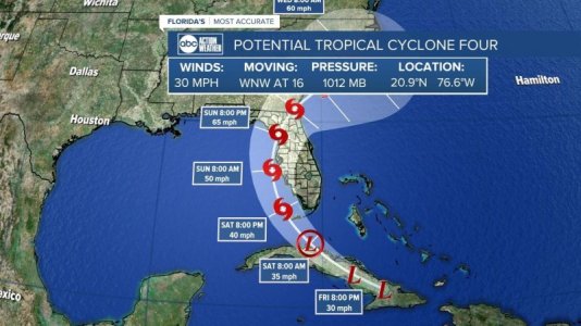
I also pay attention to Denis Phillips with ABC action news. He posted this, this morning on his Facebook page.
“Friday Tropical Thoughts. I think we finally have a pretty good handle on what's going to happen with our "Stalking Turtle" aka Debby.
1. I suspect the NHC puts us in a Tropical Storm Warning later today or tonight. They will likely issue a Potential Tropical Cyclone advisory. This allows them to put up warnings and offer a track.
2. Speaking of track, it looks like what likely will be Debby will make landfall somewhere between Pinellas and Levy County on Sunday.
3. The storm should either be a Tropical Depression or a Tropical Storm at that time. That is really the only question mark left on the table. The longer it stays over water, the stronger it could become. So, the sooner the landfall the better.
4. Impacts? Winds between 40 and 50 mph seem likely...with higher gusts. That sounds about like one of our afternoon thunderstorms, right? We will also be in the Northeast part of the storm so a "Tornado Watch" on Sunday is also possible.
5. Surge. This will be a decent-sized system that is getting stronger at landfall. There is a chance of some coastal flooding and water rise on Sunday. The water will already be higher (new moon) on Sunday so areas that are prone to flooding with storms should keep a close eye on this and plan accordingly.
6. Lots of people are asking if this could become a hurricane. Look, anything is possible, but I'm not playing the "what if" game. That spreads misinformation and its hard enough to get the forecast right with these ragged developing storms. At this point, I'm predicting a Tropical Storm with winds of 40 to 50 mph on Sunday. If it changes, you know we'll be updating 24/7 and let you know.
7. It doesn't look like it will stall so the scenario of this thing sitting in Florida for several days no longer looks like its going to happen. Rainfall of 4-6" seems likely.
8. Let's recap. Timing is late Saturday through early Monday...from our Southern counties to our Northern counties. This IS going to cut across the state so inland areas will also get wind. A Tropical Storm Warning seems likely later today as we see a PTC issued from the NHC.
9. Nothing to freak out about. We get 40 to 50 mph winds many times in the Summer. There could be some isolated power outages. Wind-wise, it's an afternoon thunderstorm that will last for several hours. But as always, for folks who flood along the coast, high tide could bring a bit of water as well. Water is always the trickiest part of the forecast because it depends on the angle the storm approaches our area of who sees the push and who doesn't.
10. I don't know if your flight is canceled and yes, it's going to rain at Disney. (That should cover 95% of the questions I get) We got this folks. This is probably good practice for what's on the way later this season. Rule #7. (Don't freak out unless I'm freaking out, we're fine) We live in Florida, this goes with the territory.”