Hurricane Sara likely to cross Gulf of Mexico next week, hit Florida on Wed 11/20. 2 itineraries in direct path, 3 more possible disruptions.

TFM1980

Earning My Ears
Joined
Jun 14, 2019
Messages
45
I saw this report come out: https://www.accuweather.com/en/hurr...aribbean-track-into-florida-next-week/1712965.

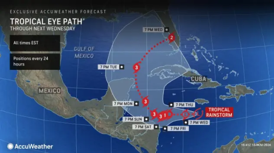
Hurricane Sara is forming in the South Caribbean and likely to cross the Gulf of Mexico Monday through Wednesday next week and hit Florida on Wednesday according to current tracking.

Here is the current path:
1731521506720.png

Here are some cruise itineraries that may be disrupted:

  • Disney Magic (November 16) - appears to be crossing the Gulf from Bahamas to Galveston right when the Hurricane will be there.
  • Disney Fantasy (November 16) - current itinerary has it moving directly into Hurricane's path (arriving in Cozumel on Monday, the same day the hurricane is arriving there).
  • Disney Dream (November 18) - in Lookout Cay the day that the Hurricane is making landfall in Florida. A delayed landfall or changing track could put it in the storm's path.
  • Disney Wish (November 18) - current itinerary has it in Castaway Cay when the storm is making landfall in Florida. A delayed landfall or changing track could put it in the storm's path.
  • Disney Treasure (November 14) - current itinerary has it in New York when the storm is making landfall in Florida. A delayed landfall could disrupt debarkation in Port Canaveral.
 
Or, since there isn't even a storm yet, the models aren't very accurate for 8 days out, and we shouldn't be making predictions that are most likely not going to be even close to coming true. I would wait to see what the hurricane hunter planes find, and then see what happens with the cold front that is moving south, and at least see if there is a single storm that gets named coming out of it before worrying about landfall. The weather talking heads are still extremely inaccurrate at 72 hours out, let alone this far without even having something for the models to focus on.
 
Last edited:
Or, since there isn't even a storm yet, the models aren't very accurate for 8 days out, and we shouldn't be making predictions that are most likely not going to be even close to coming true. I would wait to see what the hurricane hunter planes find, and then see what happens with the cold front that is moving south, and at least see if there is a single storm that gets named coming out of it before worrying about landfall. The weather talking heads are still extremely inaccurrate at 72 hours out, let alone this far without even having something for the models to focus on.
Maybe, but it is pretty clearly being projected and being reported across the media. So, probably have to trust the experts on this one...
 
As a lifelong resident of the Gulf Coast, my attitude toward longterm projections like this is that it's time to ask myself how this might affect me and to make sure I'm prepared for it if it does happen. Would I need to change my travel plans? etc.
 

Hmmm, National Weather Service is calling it "Potential Tropical Storm Nineteen"

Tropical Weather Outlook
NWS National Hurricane Center Miami FL
100 PM EST Wed Nov 13 2024

For the North Atlantic...Caribbean Sea and the Gulf of Mexico:

1. Central and Western Caribbean Sea (AL99):
A broad area of low pressure over the central Caribbean Sea
continues to produce a large area of disorganized showers and
thunderstorms. Environmental conditions are conducive for
development, and a tropical depression is likely to form within the
next day or two while the system moves slowly westward into the
western Caribbean Sea. Afterward, further development is likely
while the disturbance meanders over the western Caribbean Sea
through the weekend. The system is expected to turn slowly
northwestward by early next week. Interests across the western and
northwestern Caribbean Sea should monitor the progress of this
system. Regardless of development, heavy rains are expected over
Jamaica and the Cayman Islands during the next day or so. For more
information on this system, including gale warnings, see High Seas
Forecasts issued by the National Weather Service. An Air Force
Hurricane Hunter aircraft is scheduled to investigate this system
tomorrow morning.
* Formation chance through 48 hours...high...90 percent.
* Formation chance through 7 days...high...90 percent.


High Seas Forecasts issued by the National Weather Service
can be found under AWIPS header NFDHSFAT1, WMO header FZNT01
KWBC, and online at ocean.weather.gov/shtml/NFDHSFAT1.php

Forecaster Kelly
 
Not feeling good about my Fantasy trip for the coming week. We have to make travel decision early this morning since we are flying out tomorrow morning. Leaning heavily towards cancellation.
 
Hmmm, National Weather Service is calling it "Potential Tropical Storm Nineteen"

Tropical Weather Outlook
NWS National Hurricane Center Miami FL
100 PM EST Wed Nov 13 2024

For the North Atlantic...Caribbean Sea and the Gulf of Mexico:

1. Central and Western Caribbean Sea (AL99):
A broad area of low pressure over the central Caribbean Sea
continues to produce a large area of disorganized showers and
thunderstorms. Environmental conditions are conducive for
development, and a tropical depression is likely to form within the
next day or two while the system moves slowly westward into the
western Caribbean Sea. Afterward, further development is likely
while the disturbance meanders over the western Caribbean Sea
through the weekend. The system is expected to turn slowly
northwestward by early next week. Interests across the western and
northwestern Caribbean Sea should monitor the progress of this
system. Regardless of development, heavy rains are expected over
Jamaica and the Cayman Islands during the next day or so. For more
information on this system, including gale warnings, see High Seas
Forecasts issued by the National Weather Service. An Air Force
Hurricane Hunter aircraft is scheduled to investigate this system
tomorrow morning.
* Formation chance through 48 hours...high...90 percent.
* Formation chance through 7 days...high...90 percent.


High Seas Forecasts issued by the National Weather Service
can be found under AWIPS header NFDHSFAT1, WMO header FZNT01
KWBC, and online at ocean.weather.gov/shtml/NFDHSFAT1.php

Forecaster Kelly

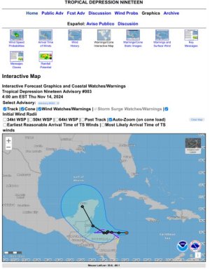
Absolutely. The NHC predicted path only goes a few days out. It’s still Depression 19 - not even named.

IMG_5568.jpeg

Proactively editing to add this is the map and info as of when I posted. So if/when it changes no one needs to quote it as incorrect.

As for the Fantasy next week, if they need to change to an Eastern or modified Western they will.

This does serve as a reminder that “season” does go through 11/30 - but also that storms don’t read calendars and can form at any time (though this one is still “in season”).
 
There was something predicted when we cruised the beginning of the month. They talked about this potential of development for two weeks before we left, while we were on the cruise. When we finally got back, hurricane Raphael finally formed. It did impact Cuba, I believe, but not cruises or anywhere else. These models aren't always accurate, hurricanes a notoriously unpredictable when they do form. It is late in the season, but storms can develop anytime really. Keep an eye on it, monitor and have your back up plan prepared when and if it does form.
 
Maybe, but it is pretty clearly being projected and being reported across the media. So, probably have to trust the experts on this one...
I am - they are saying it is too early to make predictions, and that increased interaction with landfall in Mexico is going to pretty much take away all of the energy to form a major storm, and that the cold front will knock the top off long before it can get moving toward Florida, and that will steer what is left south of the peninsula. But without any good data, the models still have nothing to chew on. But the media will hype it up - I have lived here for 30 years listening to this same crap. Just look at the change in the track you posted vs. the one put out today. completely different scenario now.
 
Disney just changed the Fantasy itinerary, so it isnt nothing.

This honestly is a case of erring on the side of caution. The models from the NHC do currently show it basically disintegrating over land, BUT it could always change directions. They decided they'd rather just change to Eastern knowing that it may in reality be nothing than go Western and either find themselves in the middle of a storm or unable to go to any of their ports.
 

GET UP TO A $1000 SHIPBOARD CREDIT AND AN EXCLUSIVE GIFT!

If you make your Disney Cruise Line reservation with Dreams Unlimited Travel you’ll receive these incredible shipboard credits to spend on your cruise!


New Posts


Save Up to 30% on Rooms at Walt Disney World!

Save up to 30% on rooms at select Disney Resorts Collection hotels when you stay 5 consecutive nights or longer in late summer and early fall. Plus, enjoy other savings for shorter stays.This offer is valid for stays most nights from August 1 to October 11, 2025.
CLICK HERE


DIS Facebook DIS youtube DIS Instagram DIS Pinterest

Back
Top