Recent Castaway Cay Map

KevieKev05

DIS Veteran
Joined
Apr 30, 2010
Here are scans of the Castaway Cap map from my recent Disney Wonder cruise (April 25-29, 2010). I know people have been curious, so hope this helps! :)

CastawayCayMap.jpg


CastawayCay-Vents.jpg
 
Thanks for posting this. I'll add a link in the stickied FAQ thread.
 
Thank you. So where on the map is the new Pelican Plunge? My understanding is that it is West of the Heads Up Bar. But that is the teen beach - so are they now letting families over there to keep an eye on their kids playing on PP?

I looked at my map from 2006 and it shows Happy hour 2 for 1 drinks at the Conched Out Bar from 1pm - 2pm. From another poster is sounds like they still have the happy hour.


Is the parasailing within the break wall? Is the water protected like it is on the family beach.
 
Thanks a bunch for posting this! It helps with the visual (for those that are cruise challenged....aka first time cruisers)!! :cheer2:
 
Is the parasailing within the break wall? Is the water protected like it is on the family beach.

Parasailing is out past the wall. Here's a few pictures I took last year while parasailing at CC (I was in the air):

9088_131.jpg


9088_133.jpg


9088_134-1.jpg


9088_135.jpg


Thank you. So where on the map is the new Pelican Plunge? My understanding is that it is West of the Heads Up Bar. But that is the teen beach - so are they now letting families over there to keep an eye on their kids playing on PP?

I looked at my map from 2006 and it shows Happy hour 2 for 1 drinks at the Conched Out Bar from 1pm - 2pm. From another poster is sounds like they still have the happy hour.

Correct...west of the Heads Up Bar is Pelican Plunge. :)

I can't remember the time, but we did indeed get 2-for-1 drinks at the Conched Out Bar...yay!
 
Thank you. So where on the map is the new Pelican Plunge? My understanding is that it is West of the Heads Up Bar. But that is the teen beach - so are they now letting families over there to keep an eye on their kids playing on PP?

I looked at my map from 2006 and it shows Happy hour 2 for 1 drinks at the Conched Out Bar from 1pm - 2pm. From another poster is sounds like they still have the happy hour.


The teen beach is moving further towards the end of the lagoon. The breakwall shown on the map doesn't actually come all the way to the beach. at the far end of the lagoon, there was a large "waste" area, that is being redone into a new teen beach. The plunge is where the teen beach used to start. If you look at the aerial shot from the parasailer, it's at the very top of the picture where the tree line ends. The tree line has been moved back, and the cabana's now line the perimeter of the old teen beach.
 
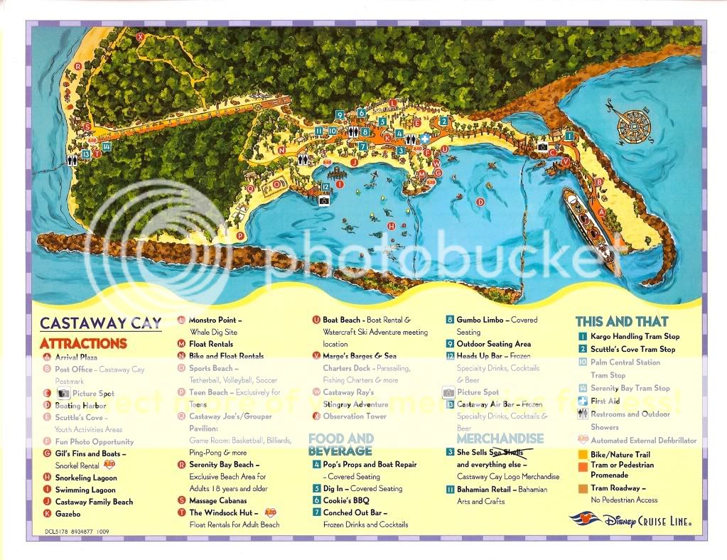
surprised that they have not updated the map yet.

Pelican Plunge Queue entrance (yes it has roped queue lines) is at location O the sports beach on the current map.

People chickened out because you have to swim in 11 feet deep water to get to the platform, hated the fact that it was salt water.

My beef was that you had to swim back to shore, exit and come back through the entrance to ride again.

When I was walking back to the ship I ask a few people if the did the plunge, and the answer was no, too far to walk. I'm guessing the crowds will be light until the new tram service starts up.
 
If anyone has something more current it would be great to see if things have changed in the last few years.
 
If anyone has something more current it would be great to see if things have changed in the last few years.

https://maps.google.com/maps?hl=en&q=castaway+cay&ie=UTF-8&ei=qfD4UJnHLPK-0QHOtoCwBg&ved=0CAsQ_AUoAA

You can tell this image is after a hurricane. Notice the brown vegetation. The salt water turns the vegetation brown. You can see the elevation by brown. Check out the sand wash out in the sea from SB end of runway. It's obvious that's the low point on the NE side. Wow, is that sand from the developed side of the island. You can see a trail of sand still on runway. It covered half the reef. Is the NE side of lagoon filled with sand, around high # family cabanas? My educated guess, time of photo, two weeks after serious storm. Are these images dated? Could this be after Sandy?
 
Ah, I thought this was new! Drat. From 2010. Why don't they do the "Cay-Vents" page anymore, that looks neat!
 

GET A DISNEY VACATION QUOTE

Dreams Unlimited Travel is committed to providing you with the very best vacation planning experience possible. Our Vacation Planners are experts and will share their honest advice to help you have a magical vacation.

Let us help you with your next Disney Vacation!


GET UP TO A $1000 SHIPBOARD CREDIT AND AN EXCLUSIVE GIFT!

If you make your Disney Cruise Line reservation with Dreams Unlimited Travel you’ll receive these incredible shipboard credits to spend on your cruise!


facebook twitter
Top